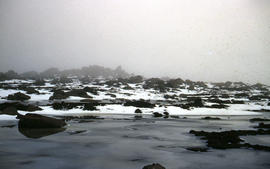
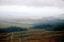
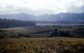
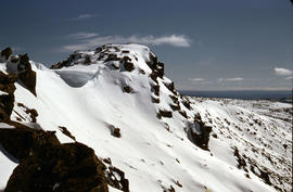
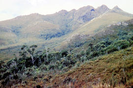
Ridgeline of Mount Mawson as viewed from Lake Dobson
- AU TAS UTAS ITCCD 2017/2-185
- Item
Part of Arthur Knight Slides
Colour photograph shows snow on the ridgeline of Mount Mawson as viewed from Lake Dobson
Ridgeline of Mount Mawson as viewed from Lake Dobson
Part of Arthur Knight Slides
Colour photograph shows snow on the ridgeline of Mount Mawson as viewed from Lake Dobson
Part of Arthur Knight Slides
Colour photograph shows snow skiers on Mount Mawson, one using a tow rope to climb uphill

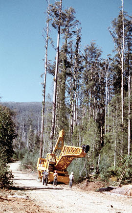
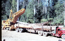
Rigger in the Florentine Valley
Part of Arthur Knight Slides
Colour photograph shows timber worker wearing hard hat, chaps and holding ropes and an axe, standing on fallen logs in the Florentine Valley
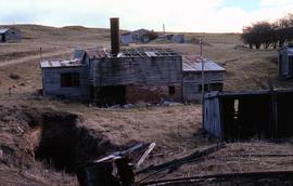
Ruins of Langloh Coal Mine near Hamilton
Colour photograph shows ruins of Langloh colliery near Hamilton
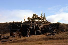
Ruins of structure at Langloh Coal Mine near Hamilton
Colour photograph shows fallen timber structures at Langloh coal mine and colliery near Hamilton
Rusted locomotive in bush near Sharpes Siding
Part of Arthur Knight Slides
Colour photograph shows rusted locomotive with vertical boiler in bush near Sharpes Siding, a siding near Lake Tyenna Valley railway.
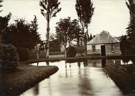
Part of Photographs of Edward Verrell
Black-and-white photograph shows the Salmon Ponds trout hatchery at Redlands, on a channel cut out of the Plenty River, near New Norfolk
Part of Hal Wyatt Collection
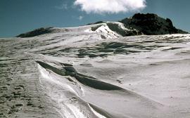
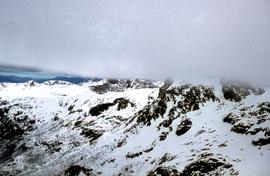
Colour photograph of waves of ice, known as sastrugi, formed near the top of Naturalist Peak, photographed in 1971
Shrub frozen at Mount Field West
Part of Arthur Knight Slides
Colour photograph shows ice formation on branches of shrub at Mount Field West, 1968
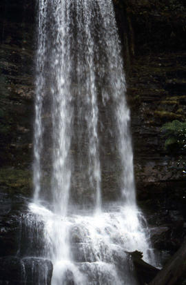
Side view of water flowing over Marriotts Falls
Part of Arthur Knight Slides
Colour portrait format photograph shows side view of the vertical drop of Marriotts Falls
Signs at entrance to Mount Field National Park
Part of Arthur Knight Slides
Colour photograph shows signs posted at entrance of Mount Field National Park, with distances and estimated travel times to Lake Dobson (9 1/4 miles), Lake Fenton (7 1/4 miles), Lady Barron Falls (1 1/2 mile), Camping Ground (250 yds), Rangers Cottage (150 Yds), Russell Falls 1/2 MILE 10 MIN, Lady Barron Falls Round Trip 3 1/2 MILES 1H 45 MIN

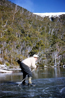
Part of Arthur Knight Slides
Colour photograph shows people ice skating on frozen surface of Lake Dobson

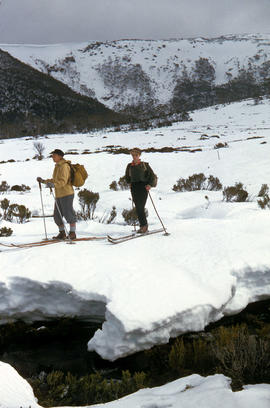
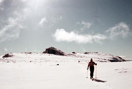
Skiers on Mount Mawson plateau
Part of Hal Wyatt Collection
Colour aerial photograph of Mount Mawson ski field with skiers visible
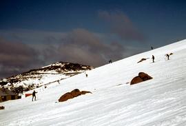
Skiing at Mount Field National Park
Part of Hal Wyatt Collection
Colour photograph of skiers at Mount Field National Park, 1968.
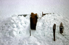
Part of Arthur Knight Slides
Colour photograph shows a snow cave excavation
Part of Arthur Knight Slides
Colour photograph shows snow covering Tarn Shelf in Mount Field National Park
Part of Arthur Knight Slides
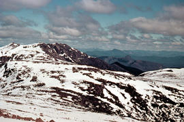
Colour photograph shows partial snow cover on Florentine Peak, looking west across mountains in distance
Part of Hal Wyatt Collection
Colour aerial photograph shows snow on Florentine Peak and Mount Field West
Part of Arthur Knight Slides
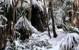
Colour photograph shows leaves of Pandani covered by snowfall

Part of Arthur Knight Slides
Colour photograph shows snow cover on the Rodway Range
Snow skier plays trick on camera
Part of Arthur Knight Slides
Colour photograph shows the tracks of a snow skier, dressed in dark clothing, going around both sides of a tree on a snow-covered, lightly wooded hill
Part of Arthur Knight Slides
Colour photograph shows two snow skiiers navigating patchy snow at National Park, a location in Mount Field National Park
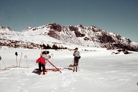
Snow skiing near Florentine Peak 1959
Part of Hal Wyatt Collection
Colour photograph shows group of snowskiers adjusting equipment near Clemes Tarn and Florentine Peak, taken in 1959
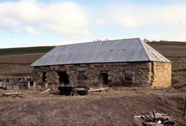
Stable ruins at Langloh Colliery
Colour photograph of abandoned Langloh coalmine and colliery near Hamilton
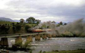
Steam train with passenger carriages crossing Derwent River
Part of Hal Wyatt Collection
Colour photograph shows steam locomotive with yellow passenger carriages crossing the Derwent River on a railway bridge near New Norfolk.
Hal Wyatt
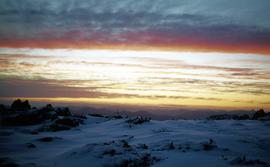
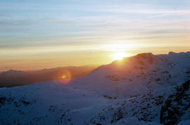
Sunset at Newdegate Pass, 1969
Part of Hal Wyatt Collection
Colour photograph of setting sun behind mountains at Newdegate Pass, 1969
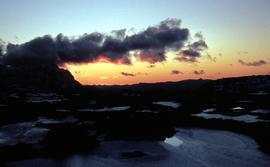
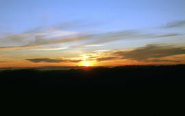
Sunset atop Naturalist Peak, 1973
Part of Hal Wyatt Collection
Colour photograph sunset atop snow-capped Naturalist Peak
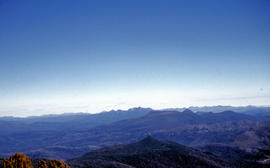
Part of Arthur Knight Slides
Colour photograph shows setting sun from the summit of Mount Field West
Part of Arthur Knight Slides
Colour photograph shows surface of Lake Dobson
Part of Arthur Knight Slides
Colour photograph shows tents pegged on snow covered ground at Mount Field West
Tents pitched at Mount Bowes campsite
Part of Arthur Knight Slides
Colour photograph shows two canvas tents pitched in hilly scrubland at Mount Bowes

The Druids as viewed from Woody Island
Part of Arthur Knight Slides
Colour photograph shows The Druids as viewed from Woody Island
The Druids near Huon River crossing
Part of Arthur Knight Slides
Colour photograph shows The Druids from near the Huon River crossing
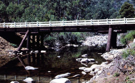
Timber bridge across Plenty River
Part of Arthur Knight Slides
Colour photograph shows the timber frame of the bridge across the Plenty River
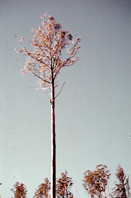
Timber worker scales tree in Florentine Valley
Part of Arthur Knight Slides
Colour portrait format photograph shows a timber worker climbing at tree in the Florentine Valley to chop down the head of the tree by hand
Timber workers tree felling in Florentine Valley
Part of Arthur Knight Slides
Colour photograph shows two bushmen, one using a chainsaw
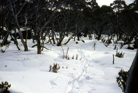
Track to Lakes Belton and Bercher under snow
Part of Arthur Knight Slides
Colour photograph shows footsteps in the snow on the track to Lake Belton and Lake Belcher
Tree cut down in Florentine Valley
Part of Arthur Knight Slides
Colour photographs shows timber worker in hard hat standing clear of a falling tree in a clearing of the Florentine Valley
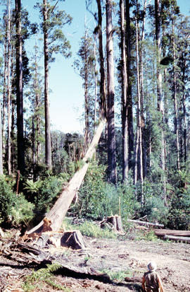
Tree falls in Florentine Valley
Part of Arthur Knight Slides
Colour photograph shows tree falling
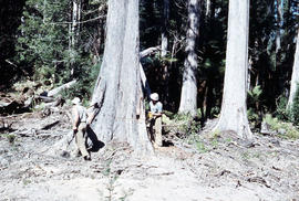
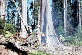
Tree felling in Florentine Valley
Part of Arthur Knight Slides
Colour photograph shows three bushmen, one operating a chainsaw, cutting into the butt of a mature eucalyptus tree, working in the Florentine Valley

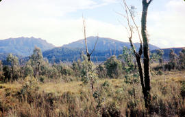
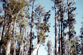
Trees on slope of Mount Mawson
Part of Arthur Knight Slides
Colour photograph shows mature forest, amid some patches of dead tree cover, on steep slope at base of Mount Mawson
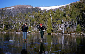
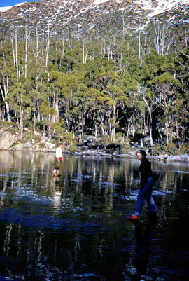
Part of Arthur Knight Slides
Colour photograph shows man and woman standing on frozen surface of Eagle Tarn, with snow-topped mountain ridge in distance
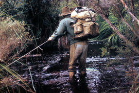
Two bushwalkers testing the waters
Part of Arthur Knight Slides
Colour photograph shows two men testing the creekbed in tea trea heathland

Vehicle on road at National Park
Part of Arthur Knight Slides
Colour photograph shows two-tone green vehicle with driver's fingers visible on steering wheel, on the unsealed road at National Park, with snow covering the higher ground. Tasmanian number plate reads WLA 189 - 19 TAS 56.
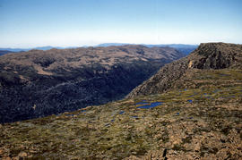
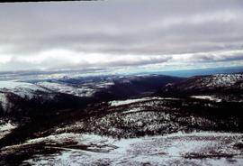
Part of Arthur Knight Slides
Colour photograph shows view of mountain range to the west of Mount Field West
View from Mount Field West across glacial valley
Part of Arthur Knight Slides
Colour photograph shows glacial valley from atop Mount Field West
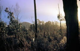
View of heathland near Mount Bowes
Part of Arthur Knight Slides
Colour photograph shows heathland looking southwest from near Mount Bowes

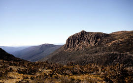
View of Mount Field West from Florentine Peak
Part of Hal Wyatt Collection
Colour photograph of Mount Field West from Florentine Peak 1966

View of Mount Mawson from Florentine Peak saddle
Part of Arthur Knight Slides
Colour photograph shows Mount Mawson viewed from saddle of Florentine Peak, with partial snow cover
View of mountain ranges west of Mt. Lord
Part of Arthur Knight Slides
Colour photograph of mountain ranges west of Mt. Lord
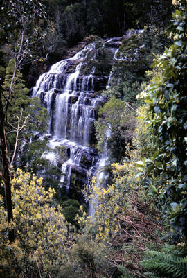
Part of Arthur Knight Slides
Colour photograph shows Russell Falls as viewed from elevated vantage point in rainforest
View of sunset from Rodway Range
Part of Arthur Knight Slides
Colour photograph shows sunset as viewed from Rodway Range
Part of Arthur Knight Slides
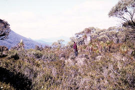
Colour photograph shows man standing on a ridge on Mount Lord, looking across the Lawrence valley, where the Lawrence Rivulet flows. Man is standing amid tall specimens of Pandani, Richea pandanifolia.
Part of Arthur Knight Slides
Colour photograph shows The Watcher
Part of Arthur Knight Slides
Colour photograph shows a bushwalker fighting to stay upright in the current while fording Sandfly Creek
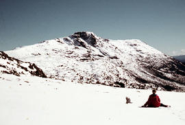
Walker sits on snow near Naturalist Peak
Part of Arthur Knight Slides
Colour photograph shows person sitting on the snow near Naturalist Peak
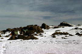
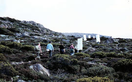
Walkers carrying building materials to K Col
Part of Arthur Knight Slides
Colour photograph shows walkers carrying building materials to build a hut to shelter bushwalkers
Walkers carrying roofing iron to K Col
Part of Arthur Knight Slides
Colour photograph shows bushwalkers carrying roofing iron along a path to the ridgeline of K Col near Mount Field West as part of project to build a hut to shelter bushwalkers and skiers. Hobart Walking Club's F.A. Peterson Memorial Hut was opened in 1960
Part of Arthur Knight Slides
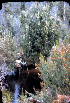
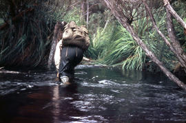
Colour photograph shows bushwalker with backpack wading through Sandfly Creek
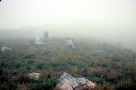
Part of Arthur Knight Slides
Colour photograph shows three walkers on heathland climbing in fog
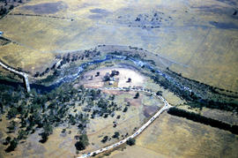
Part of Hal Wyatt Collection
Colour aerial photograph of Wombat Moor, Mount Field National Park